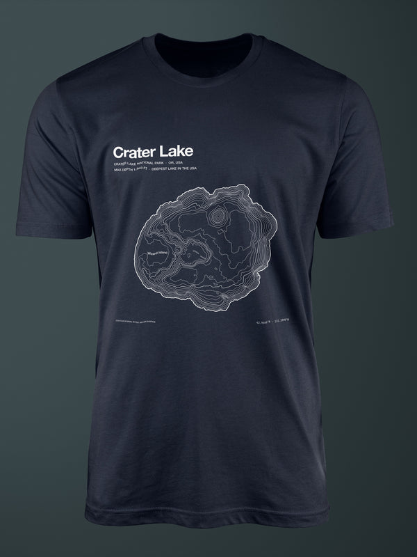
A caldera lake formed 7,700 years ago when Mt. Mazama collapsed — deepest in the US.HE-DP-26-007-CRL

Crater Lake

250 gsm archival matte stock, acid-free, FSC-certified.

$48
EditionOne terrain · three objects
TeeComplete Edition
Save $11
Print size

Museum grade · 250 gsm matte · acid-free · FSC

Free shipping in the US
Ships in 5–9 business days

Paper & printing

Printed on 250 gsm archival matte stock — acid-free, FSC-certified, museum grade. Pigment inks, fade-resistant for decades.

Printed image area 45×60 cm (18×24″). Sheet shipped unframed, flat and protected.

Shipping & returns

Made to order. Each piece is printed for you after you order — nothing is pre-stocked.

RegionShippingTransit
USAFree5–9 business days
International Join waitlist Not shipping yet

Returns & exchanges.

Every piece is made to order — no pre-stock, no waste. That changes how returns work.

  • Damaged, defective, or the wrong item shipped to you: free reprint or refund. Email within 30 days with your order number and a photo.
  • Doesn’t fit when you try it on: we can’t offer free size exchanges (reprinting + reshipping means a full second production run). Please check the Bella+Canvas 3001 size chart on the product page. If the fit is really off, email us — we help case by case with a discounted reorder or store credit.
  • Prints and change of mind: archival prints cannot be exchanged or returned. We don’t accept returns for buyer’s remorse on any item.
  • Complete Editions ship as two separate packages (tee + print) and may arrive on different days. Tracking provided for both.
  • Refunds and store credit processed within 5–10 business days of confirmation.

Questions? orders@horizoneditionsstudio.com

Buying as a gift

Sending this to someone? Here’s how a gift order works.

  • Turn on “This order is a gift” in your cart. One switch covers the whole order.
  • It ships straight to them. At checkout, enter the recipient’s address under Shipping and your own email under Contact — the confirmation comes to you.
  • Add a gift message. It travels with the order, and we email it to the recipient when the gift ships.

Not sure which format suits them? See more gift ideas →

Design: 100% human-made by a professional graphic designer, from the real data specified on this page. Marketing photos may use an AI-composited mockup scene — the design itself is always the exact file we sell.

↓ 1,943 FT DOWN

A caldera lake. Mt. Mazama collapsed here 7,700 years ago.

A caldera lake formed 7,700 years ago when Mt. Mazama collapsed — deepest in the US.

— The Story

A mountain collapsed. Rain did the rest.

My water is almost unnaturally clear because nothing flows in to cloud it and nothing flows out. No rivers. Just snowmelt and rain, caught in the hollow a mountain left when it fell into itself, sinking light to depths where most lakes have long gone black.

Around 7,700 years ago Mount Mazama — once near 12,000 feet — erupted and collapsed inward, leaving a caldera eight by ten kilometers and more than a kilometer deep. It has been filling ever since. Today I'm the deepest lake in the United States at 1,943 feet, and the rim that survived the collapse still stands over 8,000 feet at Hillman Peak. You are looking at the inside of a volcano, filled with the sky.

The contour on this piece is my real floor, drawn from the USGS sonar survey of the lake bed — the shape of the collapse, to scale.

No rivers feed it. The water is snowmelt, and it is almost perfectly clear.
— The lake, in numbers

A caldera,measured to the foot.

↓ 1,943 FT · DEEPEST IN THE U.S.
MOUNT MAZAMA CALDERA · OREGON
Max depth1,943 ft592 m · deepest lake in the U.S. (NPS)
Average depth1,148 ft350 m
Surface area21 mi²54 km² (NPS)
Caldera formed~7,700 yr agoMount Mazama climactic eruption
Water clarity142 ftSecchi-disk record, 1997 (NPS)
Caldera rim8,151 ftHillman Peak · highest point
— The object

How it's made.

Archival terrain on 250 gsm matte stock. Museum-quality archival print. Made to outlast the wall it hangs on.

Paper

250 gsm archival matte stock. Acid-free. FSC-certified.

Print method

Museum-quality archival print with pigment inks. Designed for long-term display under normal indoor light.

Production

Made to order in the United States. Printed and shipped within a few business days.

Framing

Designed to fit a standard 18×24 in frame. Shipped flat in a rigid mailer.

— Provenance

Every line,traceable.

◉ Terrain

Archive ID HE-DP-26-007-CRL
Trophy ↓ 1,943 FT DOWN — A caldera lake. Mt. Mazama collapsed here 7,700 years ago.
Terrain Crater Lake · 42.9446 · -122.109 · North America
Source USGS 3DEP + USGS bathymetry · 10 m DEM
Dataset / version USGS 2000 multibeam bathymetry (2 m) + USGS 3DEP topography · 10 m DEM
Resolution 10 m contouring grid · lake floor surveyed at 2 m (USGS/NPS, 2000)
Contour interval Source: USGS / NPS Crater Lake DEM · 10 m · Rendered: 50 ft
Projection EPSG:26910 · NAD83 / UTM zone 10N

◉ Method

Extraction QGIS 3.34 · contour extraction from source grid
Editing Human vector cleanup in Illustrator · no smoothing algorithms applied
License Public domain · USGS/NPS bathymetric survey
AI use None in the terrain. No generative models, no style-transfer, no AI autocomplete, no automated contour simplification — at any stage of extraction or editing.
Verification Cross-checked against the USGS/NPS 2000 bathymetric survey
Issue 04 · Spring 2026
Provenance Verify this Archive ID →
— The gift

Made to be received.

Built to be opened slowly. A considered piece for someone who knows the place — or wants to remember it.

Gift ready

A considered terrain piece for someone who knows the place — or wants to remember it.

No size guessing

The archival print makes a strong gift when sizing is uncertain.

Ship to them

Send it directly to the recipient at checkout. Order confirmation and tracking stay with the purchaser where supported by Shopify.